
Trying to cycle from the shops at Wright, Molonglo Group Centre or Whitlam to CIVIC will not be easy without good planning. Molonglo Valley currently lacks good design for cycling. The Molonglo River Reserve Management Plan makes it harder, as cycle infrastructure is needed in the reserve area. Cyclist are expected to ride around the reserve area which, as can be seen from maps in this article, will be a long ride.
Good idea done badly
Back in 2004, when the spatial planning was done for Canberra, the Molonglo Valley seemed like a good idea. That was before a decade of environmental studies between 2011-2019 that saw the south of the Molonglo Valley cut off from the north and Civic now very distant.
One option would have been to align the main corridor of the Molonglo Valley in an east-west direction to provide the shortest distance to the city. This did not happen. John Gorton Drive has become the main corridor of the south Molonglo Valley urban area, and it runs north-south. A cyclist riding along John Gorton Drive to the city, follows a dog leg route far to the south or the north, before finally turning west – a massive detour.
Of course, the situation could be improved with many cycling bridges but Molonglo River Reserve Management Plan makes bridge approvals very difficult. This will leave the south of the Molonglo Valley cut off from the north. C’est la vie.
The Molonglo Valley southern suburbs have now reached a late stage of the development and it is apparent that the options for commuting to Civic in the future will remain limited. Some improvements will occur over the next 20 years with the construction of the east-west bridge but the cycle route remains convoluted, nevertheless.
Three shopping centres
Local shopping centres are planned at Wright and Whitlam. Both should be well advanced around 2025. Hopefully, by that time, the John Gorton Drive bridge will also be finished which will provide a way to travel between them (north-south). In the middle is the location of the future Molonglo Group Centre (town centre). We will not see the first parts of the Molonglo Group Centre until 2030, as there is so much that still needs to be done. The Molonglo Group Centre Concept Plan has been released though and waiting for your critique.
Spatial planning
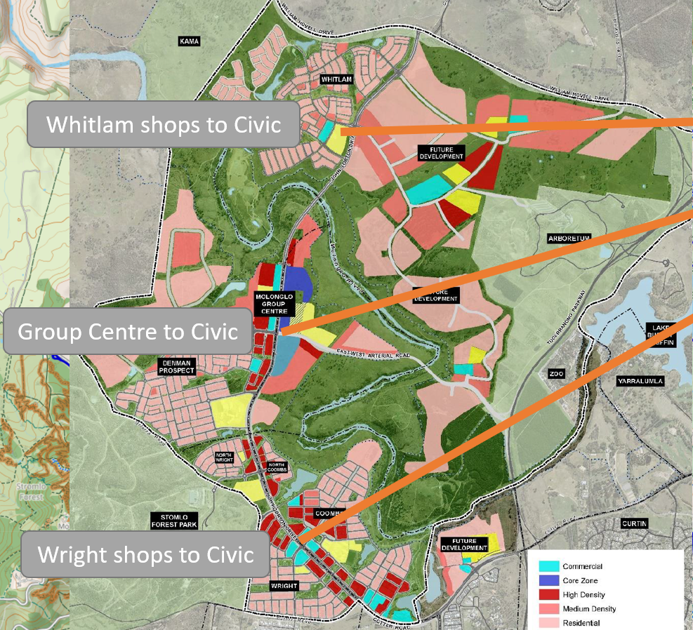
The first map shows the location of the shops on the left. Listed from north to south the shops are
- Whitlam Local Shops,
- Molonglo Group Centre and
- Wright Local Shops.
The RED boxes along John Gorton Drive, running north-south, are high density housing. The ORANGE lines show the direct line-of-sight to Civic which represents the theoretically optimal cycling route. Geographical features intervene, that are exasperated by poor planning. We will consider each of these routes in turn.
Remember, Bike routes should be direct and as flat as possible. The lack of bridges over the Molonglo River make a good bike route impossible.
Overview map showing the shops in the Molonglo Valley relative to Civic

Close up map of the Molonglo Valley Concept Plan

Analysis of the 3 routes
Whitlam shops to Civic
Whitlam local shops to Civic route looks good for starters until we see that the line-of-sight crosses Black Mountain. Riding to the north around Black Mountain is a major detour. Riding to the south of Black Mountain is hampered by the huge aerial road network made of Gungahlin Drive, Parkes Way and Tuggeranong Parkway, that all converge at Glenloch Interchange.
Any bike path will have to be built around these obstacles, which will make the route much more indirect than we would like.
The good news is that the upgrade of the LBG bike path is planned (and long overdue). The LBG bike path vital corridor and backbone to ALL future routes from the Molonglo Valley. Unfortunately, we not see the improvements until the 2030s.
Group Centre to Civic
The Molonglo Group Centre is not in the heart of the Molonglo Valley but really the north. The suburbs are built along John Gorton Drive so that the suburbs are much longer than wider. This elongated design by itself is poorly suited to active travel. John Gorton Drive lacks grade separated bike paths along its length. Cycle lanes are provided instead which is wasted paint. Most people will not ride on cycle lanes – one reason why cycling mode share is so low in the ACT.
The line-of-sight between Molonglo Group Centre and Civic crosses the tall hill in the National Arboretum. As with the Whitlam local shops to Civic and Black Mountain. The choice is to go north or south of the hill, and the southern route is arguably better.
Molonglo Group Centre will be connected to the east to Civic in the 2030s by the east-west bridge. Should an off-road (grade separated) bike path be build from the Molonglo Group Centre to the LBG bike path, the travel time will be minimised.
Wright shops to Civic
Wright Local Shops to Civic is closest to the CBR Cycle Route C5 between Tuggeranong and Civic. Should a decent 4 m wide, direct grade separated path be built to it, that would be the quickest route as the CBR Cycle Route C5 is quite flat.
Certainly, the other two route discussed above from the Group Centre or Whitlam would be much longer for people living in the south.
Conclusion
The Molonglo Valley is a pretty place but the topography and policy choices have made the south difficult to reach on a bike from Civic. All transport modes fail the residents of Molonglo Valley south and it is likely to remain so for the foreseeable future.
For cyclists who work in the city, commuting from the Molonglo Valley is hard work. Many Canberra suburbs are far more attractive for commuting.

