
The active travel facilities planned for Whitlam Stage 2 fall short of expectations. As human behaviour follows infrastructure, this lack of future proofing active travel facilities is directly detrimental to achieving an increase in active travel in the ACT.
Contents
- Introduction
- Background to the Molonglo Valley
- ACT Climate Change Strategy 2019-25
- Active travel design
- Example: Whitlam Stage 2 and active travel
- Conclusion
- References
- Attachments
Introduction
The TCCS Active Travel Design workshop on 12 December 2018 noted that the reasons for new Active Travel Design Guidelines included “poor infrastructure outcomes as a consequence of planning intent getting ‘lost in translation’”. Canberra.bike concludes that this observation is likely relevant for the planning of the brand-new estate Whitlam. Our concern is that the failure to systematically integrate active travel principles in the planning process, as well as the dominance of decade old legacy planning practices, will result in the missed potential to develop active travel facilities in the Whitlam and other new estate developments in Canberra. Consequently, this will not only make the roads less safe for vulnerable road users but also not achieve any set active travel goals.
What you will find here
- A description of what is wrong with the estate design for Whitlam Stage 2.
- Background information will be provided on the Molonglo Valley estates development, for Molonglo Valley Stage 3, and Whitlam Stage 2 in particular.
- Linking the goals of the ACT Climate Change Strategy 2019-25 to active travel and implications for planning using Active Travel Facilities Design – Municipal Infrastructure Standards 05 (MIS05).
- List of relevant ACT Standard Drawings (ACTSD) for active travel for Whitlam.
- An example illustrating the problem: “Road 01” in Whitlam Stage 2 and the Local Community Path along it – the intersections are not designed in a way suitable for active travel or compliant with the MIS05 standard.
Background to the Molonglo Valley
The Suburban Land Agency is a statutory authority established under the City Renewal Authority and Suburban Land Agency Act 2017. The Suburban Land Agency is responsible for delivering the ACT Government’s suburban development program, including the development of the Molonglo Valley.
Molonglo Valley, at capacity, is planned to accommodate approximately 55,000 new residents. Land development in Molonglo Valley was planned in three stages: Stage 1 consisting of the suburbs of Coombs and Wright, and the region of North Weston, Stage 2 the suburbs of Denman Prospect and Molonglo, and Stage 3 the suburbs north of the Molonglo River. Stage 1 and 2 are largely complete.
On 27 February 2019, the Molonglo Valley Stage 3 Planning and Design Framework was finalised. A framework is a strategic plan to guide future detailed planning, and in this case for the new suburbs north of the Molonglo River. Whitlam is the first suburb in Molonglo Valley Stage 3. Whitlam lies west of John Gorton Drive. Many more suburbs are planned on the east of John Gorton Drive extending to the National Arboretum (Molonglo 3 East FUA).
The Whitlam estate development has a staged land release: stage 1 from early 2020, stage 2 from late 2020 – early 2021, stage 3 2022 and stage 4 in 2023. The first land release in Whitlam in stage 1 is set for March 2020.
Molonglo 3 East Planning and Infrastructure Study Project Brief design tender (2 December 2019), released by the Major Projects Canberra Infrastructure Delivery Partner Group, is for the first stage design of Molonglo 3 East, but not for Whitlam, a signal that the first stage planning of these new, yet unnamed, suburbs has begun. To quote the brief, the ACT’s Indicative Land Release Program 2019-20 to 2022-23, “proposes 200 blocks be released in the study area by 2022-23.”
ACT Climate Change Strategy 2019-25
In 2019, the ACT Government released the ACT Climate Change Strategy 2019-25. Active travel is one important pillar of this strategy:
“Once emissions from electricity are zero, transport will account for around 62%.” Key priority: “encourage active travel by continuing to improve cycle paths and walkability.” Further, it “will require substantial changes in the way we plan and build our city“, and “there will need to be a greater emphasis on increasing active travel (for example, walking and cycling) and public transport use to reduce transport emissions to 2025.” Actions (goals) from the ACT Climate Change Strategy to 2025 include:
“3D Encourage active travel
3.8 Implement the Municipal Infrastructure Standards for Active Travel (ed. MIS05) and develop best practice guidance for industry and stakeholders to inform better design outcomes for active travel infrastructure.
3.9 Prioritise walking and cycling and enhance active travel infrastructure to improve safety and connectivity of the active travel network.”
“3E Reduce car use
3.15 Investigate and implement options for encouraging a shift to public transport and active travel through planning…”
ACT Climate Change Strategy 2019-25
Active travel design
Active travel is supported by many documents and planning resources. References for active travel in the ACT include:
- Building an Integrated Transport Network: Active Travel (May 2015)
- Variation of the Territory Plan No 348: Incorporating Active Living Principles into the Territory Plan (27 October 2017)
- Planning for Active Travel in the ACT: Active Travel Infrastructure Interim Planning Guideline (January 2019)
- Active Travel Facilities Design – Municipal Infrastructure Standards 05 (MIS05) (April 2019)
The Active Travel Facilities Design is supported by the Active Travel Infrastructure Practitioner Tool which include the ACT Standard Drawings (ACTSD) for active travel to download.
Particularly relevant to the new estate development are the following Standard Drawings.
- ACTSD-0521 mid-block paths crossings MCR
- ACTSD-0527 mid-block driveway crossings for paths (shared) MCR and LCR
- ACTSD-0528 side street crossings for paths (shared) MCR and LCR

Example: Whitlam Stage 2 and active travel
Document: Whitlam Stage 2 Development Application 201936061, 10 September 2019.
Local community route
A complete assessment of the Whitlam Stage 2 development application is beyond the scope of this text. The text focuses narrowly on one example to illustrate how the design falls short supporting the active travel pillar in the ACT Climate Change Strategy 2019-25. Specifically, the discussion is about the requirements of a Local Community Route (LCR) along the lower section of Sculthorpe Avenue. At the time that the Whitlam Stage 2 development application was released, the roads had not yet been named, and the roads were numbered instead. Sculthorpe Avenue is labelled “Road 01”. Local shops and a school will be built adjacent to Sculthorpe Avenue.


Vulnerable road users
The Local Community Route (LCR) along Sculthorpe Avenue is poorly designed for vulnerable road users, in particular children. With a school and shops close by many children can be expected to walk along the route. The crossing on the side roads has the path set back so that children are hidden by any car waiting at the side road. This can be seen on the plan “Road Details Plan – Sight Distance”, showing the line-of-sight between cars driving along Sculthorpe Avenue and cars entering from a side road.
Safety is important for motorists but much more effort needs to be made to protect vulnerable road users from motor vehicles.
A Local Community Route zigzags along the north of Sculthorpe Avenue from east to west, crossing side roads 52, 57, 58 and others. This type of intersection design has rightly been criticised in the recent Austroads safety report Movement and Place for Vulnerable Road Users.


Safe Systems
Offsetting the path crossing from the intersection is intended to provide good visibility by allowing cars to stop at the edge of the intersection. However, this leads to an avoidable risk to vulnerable road users as the Local Community Route is an unmarked crossing.
Better and safer designs slow the vehicle before crossing. With lower speeds the driver is more likely to see pedestrians and cyclists, and be able to stop.
Austroads promotes “Safe Systems” that protect vulnerable road user. For example, raised platforms are easily visible, and marked with signs and on-road markings. It shifts the stopping line forward to the edge of the platform and provides pedestrians and cyclists with more safety.
Safe Systems are found in the ACT Active Travel Facilities Design standards (MIS05). Along the local community route, the relevant design standard is Side Street Crossing Treatments (on platforms) for paths (shared) on Main and Local Community Routes (ACTSD-0528). Both “continuous verge treatment” or “zebra crossing” feature a raised platform at the same level as the adjacent verge.

Road 52/Road 01 intersection after construction
The interesctions along Sculthorpe Ave are designed for high speed motoring and provide little encourage to slow cars and make crossing the road easier. Whitlam was built for cars and it shows.
Road 52/Road 01 intersection after construction of Whitlam Stage 2, taken on the 8 June 2022. Road 52/Road 01 are the names of the roads found on Whitlam Stage 2 Estate Development Plan (see above). Now the roads are called Bousloff Street and Sculthorpe Ave respectively.
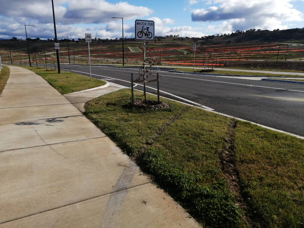
Figure 1 shows Bousloff Street intersection, looking towards John Gorton Drive. The local shops and primary school will be built on the other side of the road. When completed, we can expect many children to cross here walking to and from home. Considering the number of vulnerable road users that are likely to be seen here, the intersection does little to make crossing for children safe. Further this path is officiallly a Local Community Route (LCR).

Bousloff Street is a long stright street down a hill that provides reason for cars to slow down (figure 8). The photo is taken looking up the hill to Hazel Hawke Avenue. The local shops site is on the right on the hill.

Figure 9 shows the pedestrian view, for a person waiting to cross Bousloff Street. The road is wide and cars turning left into Bousloff Street from Sculthorpe Ave can turn at speed. A zebra crossing here would force cars to slow down before the turn and provide pedestrians with some protection.

Traffic island trouble
Traffic islands are common but not the best design and there are better options. A traffic island narrows the road lane. Drivers rarely slow down which makes cycling through the narrow dangerous. Because cars continue to travel straight they have little reason to brake which makes pedestrians crossing the road too. Most collisions with pedestrians are at travel speed and the driver never brakes. The island provides better protection by reducing the distance one needs to walk by about half.
An better option is to reduce the width of the road by road narrowing around the crossing point. A road is easier to cross if the road is not as wide, particularly for the elderly. Road narrowing encourages drivers to slow because the perceive the road narrowing a restriction. Until cars pass/stop the pedestrian can wait in safety on the curb. This is particularly valuable when many people wish to cross together at busy intersections such as around schools and shops.
Figure 10 shows a signed knock flat on the traffic island on Sculthorpe Avenue, close to the Bousloff Street. Children living in Whitlam Stage 3 (to the south of Sculthorpe Avenue) may need to cross the road here walking home. Only months after the streets where opened the signs have alread been flatten. It bodes poorly for the safety of pedestrians.
Figure 11 shows that both signs have been flattened on this traffic island on Sculthorpe Avenue.

Pedestrian crossing with traffic island looking north on Sculthorpe Avenue, close to the Bousloff Street. From the safety of one curb to the other is a long way.
Primary children could not cross here without help of an adult as they are crossing a high speed major collector. Children would require a signalised crossing to cross a major collector. Primary school children do not have the cognitive ability to judge vehicle speed or distance. Although this is well known (Austroads), we continue to build suburbs like Whitlam where children can cross roads without adult supervision which makes it impossible for the children to get around independently.

Traffic island make the cycle lane unsafe for cyclists. The traffic island on Sculthorpe Avenue, close to the Bousloff Street, includes exit point for bikes to leave the cycle lane and continue along the community path past the traffic island. The traffic island is a narrowing of the road lane and cycle lane ends just before it.
Conclusion
The failure of the Whitlam Stage 2 Development Application design is that it includes design elements that neither safe nor compliant with the MIS05. The ACT Government is unlikely to achieve its Climate Change Strategy goals if we do not build for active travel. We have a climate emergency and need to consistently apply an emergency action mindset for any planning activities in Whitlam.
References
A. Whitlam Stage 2 Development Application 201936061, 10 September 2019.
- Active travel map, Whitlam Stage 2 Development Application, PLAN-201936061-ACTIVE_TRAVEL_NETWORK-01
- Road details map, Whitlam Stage 2 Development Application, ROADDETAILS-201936061-01
- Road Details Plan – Sight Distance (sheet 3 of 5), Whitlam Stage 2 Development Application, ROADDETAILS-201936061-03
B. ACTSD-0528 Side Street Crossing Treatments (on platforms) for paths (shared) on Main and Local Community Routes, ACTSD-0528-Rev0-180929
